


© COPYRIGHT 2003-2007 www.BoatHarborsLocator.com
All Rights Reserved
Terms of use and Privacy Policy

|
 |
| Marine Weather - Wave and Wind Patterns - Predications |
|
| PLEASE VISIT OUR WEBSITE SUPPORTERS |
|
|
|
|
|
|
| |
|
|
| |
Wave, Wind and Weather Data
|
| |
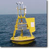 |
California Buoy Data
Click here to access California Buoy Data
|
| |
|
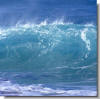 |
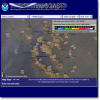
| Ocean Wave Pattern Data |
| Click here to access NOAA wave pattern map (must have Java enabled browser) |
| Northeast Regional Pacific Ocean Wave Model |
| Wave Height Animation Period Animation |
| California Swell Model |
| SF Bay Area Monterey Bay Area Central California Southern California |
|
| |
|
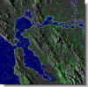 |
Real-Time San Francisco Bay Area Wind Pattern
Click here to access wind pattern map
(must have Java enabled browser)
|
| |
|
 |
nowCOAST: NOAA GIS Mapping Portal
For real-time environmental observations and NOAA forecasts click here.
|

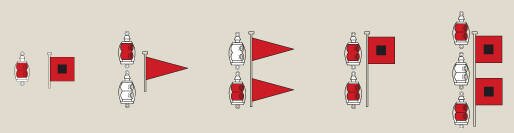
Storm Warning Signals
Signals are displayed when necessary at principal harbors, yacht clubs and Coast Guard stations & vessels.
| Night Signal |
Day Signal |
Winds to 38 mph Gale |
Winds 39-54 mph Storm |
Winds 55-73 mph Hurricane |
Winds 74 mph & up |
SPECIAL MARINE WARNINGS
 |
San Francisco, CA |
|
San Diego, CA |
|
Seattle, WA |
|
Medford, OR |
|
|
Los Angeles, CA |
|
Eureka, CA |
|
Portland, OR
|
|
PACIFIC OCEAN FORECASTS & WARNINGS
|
North Mid - Pacific Highseas |
|
Marianas (Guam) |
|
Samoa |
|
|
South Mid - Pacific Highseas |
|
Micronesia
|
|
HIGH SEAS FORECASTS
|
East Pacific |
|
Northeast Pacific |
|
Mexico Highseas |
|
|
North - Mid Pacific |
|
South - Mid Pacific |
|
Peru Highseas |
|
|
|